The need for good maps in Asia began early in history thanks to extensive overland and maritime trading between the many states and kingdoms… and when looking at more modern maps of the Far East and Southeast Asia you will soon run into the history of the East India Companies in the region.
Here are some cartographic resources which reveal the companies’ and Western colonial powers’ own cartography as well as a selection of other useful maps and illustrations of trade routes.
The link to the information is given under each image. Where a high resolution version of the map is available online publicly I’ve linked from our smaller image here to the main file.
1. Dutch East India Company trade network in the 18th Century

Regional trade and indications of main export/import products
VOC i.e. Dutch East India Company (Verenigde Oost-indische Compagnie) trade routes map by Dr. Jean-Paul Rodrigue, Dept. of Global Studies & Geography, Hofstra University
2. 1783 Bonne Map of India, Southeast Asia, and East Indies
The map below includes extensive inland detail: it was drawn by Rigobert Bonne for Lattre’s Atlas Moderne.

Geographicus.com has an extensive gallery of antique maps for sale, see this page for the Antique maps of the East Indies.
3. Pinkerton’s 1818 map of the East Indies
This map is a copperplate engraving showing the “East India Isles” showing the south of Myanmar (Burma), Thailand, Cambodia, Vietnam, Laos, and Indonesia and the Philippines.
The map shows the island of Rakata (on the map “Rakama”) which was where Krakatoa erupted in 1883, changing that part of the map!

The Dutch East India Company colonies were nationalized in 1800 . Read more about the trading and colonial history of the “Dutch East Indies” on Wikipedia.
4. 1840 Map of Dutch Colonial Possessions
In the post-Napoleonic era, the Kingdom of the Netherlands steadily expanded its colonies in the region of modern-day Indonesia.

Read more about the history of the Dutch imperial / colonial era on Wikipedia here.
5. The growth of British East India Company territories 1765-1857
The following maps from the 1907 Imperial Gazetteer of India illustrate the expanding areas of control of the East India Company in the Indian Subcontinent.


Originally under the “English East India Company”, founded in 1600, the trading activities of the British in India quickly became about asserting territorial control. Read more about “Company rule in India” at Wikipedia here.
6. 1864 Johnson and Ward map of “Hindostan; or British India”
This map shows the extent of “The Raj” at its height.

Full details about the above map and the 1864 Johnson’s New Illustrated Family Atlas can be found here on David Ramsey Map Collection site.
7. Imperial Gazetteer of India (c1910) maps of Burma
The following map images link directly to their full size images hosted by the University of Chicago:


Imperial gazetteer of India maps resource at the University of Chicago Digital South Asia Library.
Zum.de has an authoritative map-based guide to the extent of the national boundaries of Burma since the 16th century here.
8. Early Southeast Asian trade routes
Long before the Europeans’ imperial ambitions, of course, were local empires. From the 9th century to the 13th century, an important seagoing power were the Cholas. During the same period, maritime trade routes developed between kingdoms of Srivijaya, Kediri, Khmer, and Champa:

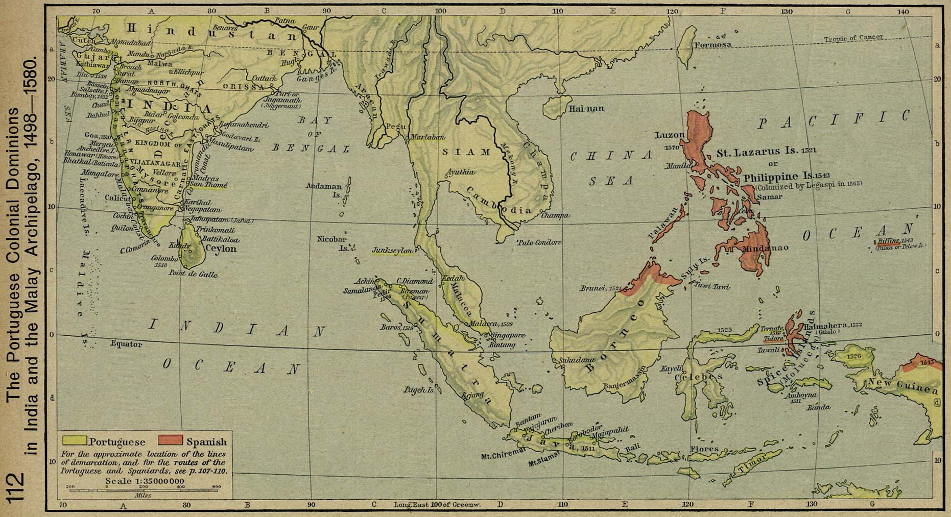
9. Medieval and Portuguese commerce in Southeast Asia
Contemporary mapping from the era of Portuguese seafaring is a fascinating topic in itself.
In the map below we can see some of the early map conceptions of the coasts of Southeast Asia, and then some modern atlas explanations of trading routes.


10. The Selden Map of China
This 17th century Chinese map, “rediscovered” in a collection in 2008 and much discussed by historians, shows Southeast Asia to a good degree of accuracy. It was probably copied from Japanese and Portuguese navigation maps of the time.

Read more about the Selden map in “Treasures of the Bodleian” here.