We’ve put together a short slideshow introducing Borobudur to help you start planning your trip (or pilgrimage!) there…
Visiting Borobudur: A Quick Introduction
from Buddhist Architecture
We’ve put together a short slideshow introducing Borobudur to help you start planning your trip (or pilgrimage!) there…
Visiting Borobudur: A Quick Introduction
from Buddhist Architecture

Once an important trading centre, Ayutthaya is now an archaeological ruin in Thailand. Its vast complex of prangs and giant temples are one of Thailand’s must see sights. Here’s how to get the best out of your first visit to this ancient city.

Ayutthaya was founded in 1350 and became Thailand’s second capital city after the era at Sukhothai. During the 14th to the 18th century Ayutthaya became an important trading centre as well as a cosmopolitan city. Its position above the tidal bore in the Gulf of Siam and the location on an island made it very powerful and linked the city to the sea, but also helped defend it from attack by ships.
By 1700 Ayutthaya was the largest city in the world and has 1 million inhabitants. In 1767 the Burmese invaded and destroyed Ayutthaya. All the inhabitants were forced to leave and the city was abandoned to become the huge archaeological treasure that it is today.

Ayutthaya is a huge complex stretching over a wide area. The Ayutthaya Historical Park is one of Thailand’s biggest tourist attractions and is divided into the sights on the island and those off the island which are best reached by boat.
One of the most important places to visit in Ayutthaya is the Tourist office which has excellent displays of the city and also houses the city museum where a lot of the history and archaeological events can be seen.
Wat Bhuddhaisawan is important architecturally as it was constructed in 1350 and believed to be the first temple built in the Khmer style in Ayutthaya. It was heavily plundered in 1767 but today is known for its reclining Buddha and the two Buddha footprints.
Wat Chai Wattaranam is one of the most photographed sites in Ayutthaya because of its distinctive Khmer style Prangs. These stand 35 metres high and were constructed in 1763 by King Prasat Thong.
Wat Phanang Choeng is another ancient temple built in 1324 and existed before the city of Ayutthaya. It is interesting for its structure and age, and is still in use by locals today.
The city had three palaces and Ban Pa In Palace can still be visited. It is south of the main city and has remains of the palace as well as the Chumphon Kikarayam temple. The Chankarasem Palace is on the banks of the River Prasak and was built during the reign of King Maha Thammaraja. It was destroyed in the Burmese invasion but has been restored and is an interesting national museum.
Phu Khao Thong was constructed by the Burmese and its 76 step chedi is worth a climb for the views across the city and temples. Watching a sunset over the temples is a major attraction here and stunning to watch.
The nearby Elephant Kraal is very popular with visitors to Ayutthaya and is the perfect place to relax after a day viewing temples. Chao Phrom Market is popular with visitors and sells food, clothing and other items.
There are direct trains and buses from Bangkok to Ayutthaya which are inexpensive and easy to navigate. There are also tours operating from Bangkok.

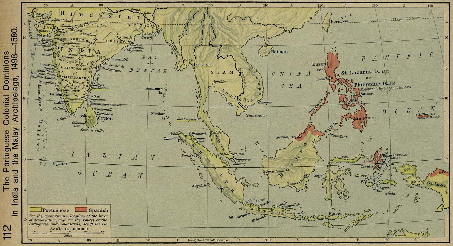
The need for good maps in Asia began early in history thanks to extensive overland and maritime trading between the many states and kingdoms… and when looking at more modern maps of the Far East and Southeast Asia you will soon run into the history of the East India Companies in the region.
Here are some cartographic resources which reveal the companies’ and Western colonial powers’ own cartography as well as a selection of other useful maps and illustrations of trade routes.
The link to the information is given under each image. Where a high resolution version of the map is available online publicly I’ve linked from our smaller image here to the main file.

Regional trade and indications of main export/import products
VOC i.e. Dutch East India Company (Verenigde Oost-indische Compagnie) trade routes map by Dr. Jean-Paul Rodrigue, Dept. of Global Studies & Geography, Hofstra University
The map below includes extensive inland detail: it was drawn by Rigobert Bonne for Lattre’s Atlas Moderne.

Geographicus.com has an extensive gallery of antique maps for sale, see this page for the Antique maps of the East Indies.
This map is a copperplate engraving showing the “East India Isles” showing the south of Myanmar (Burma), Thailand, Cambodia, Vietnam, Laos, and Indonesia and the Philippines.
The map shows the island of Rakata (on the map “Rakama”) which was where Krakatoa erupted in 1883, changing that part of the map!

The Dutch East India Company colonies were nationalized in 1800 . Read more about the trading and colonial history of the “Dutch East Indies” on Wikipedia.
In the post-Napoleonic era, the Kingdom of the Netherlands steadily expanded its colonies in the region of modern-day Indonesia.

Read more about the history of the Dutch imperial / colonial era on Wikipedia here.
The following maps from the 1907 Imperial Gazetteer of India illustrate the expanding areas of control of the East India Company in the Indian Subcontinent.


Originally under the “English East India Company”, founded in 1600, the trading activities of the British in India quickly became about asserting territorial control. Read more about “Company rule in India” at Wikipedia here.
This map shows the extent of “The Raj” at its height.

Full details about the above map and the 1864 Johnson’s New Illustrated Family Atlas can be found here on David Ramsey Map Collection site.
The following map images link directly to their full size images hosted by the University of Chicago:


Imperial gazetteer of India maps resource at the University of Chicago Digital South Asia Library.
Zum.de has an authoritative map-based guide to the extent of the national boundaries of Burma since the 16th century here.
Long before the Europeans’ imperial ambitions, of course, were local empires. From the 9th century to the 13th century, an important seagoing power were the Cholas. During the same period, maritime trade routes developed between kingdoms of Srivijaya, Kediri, Khmer, and Champa:

Contemporary mapping from the era of Portuguese seafaring is a fascinating topic in itself.
In the map below we can see some of the early map conceptions of the coasts of Southeast Asia, and then some modern atlas explanations of trading routes.


This 17th century Chinese map, “rediscovered” in a collection in 2008 and much discussed by historians, shows Southeast Asia to a good degree of accuracy. It was probably copied from Japanese and Portuguese navigation maps of the time.

Read more about the Selden map in “Treasures of the Bodleian” here.

No other city around Thailand (or hardly anywhere similar in the world) has such a tactful name – “Defeat of Siam”; given that actually Thailand defeated Cambodia and reigned over Siem Reap from 1794 to 1907.
Siem Reap started blooming for the first time during the Golden 1920’s when the legendary Grand Hotel d’Angkor was built and high-profile guests like Charlie Chaplin started visiting the city and Angkor Wat.
But the recovery should not last long – the Khmer Rouge led Siem Reap and its people again into decades of darkness until the mid-1990’s.
Fast forward 2014, Siem Reap has turned into a bustling city with plenty of hotels and restaurants and transformed the city into the heartbeat of Cambodia’s tourism, mainly due to its proximity to the magnificent temples of Angkor Wat.
08:30 – Angkor National Museum
Visiting the Angkor National Museum prior to visiting the legendary Angkor Wat will give you a better understanding about the Khmer Empire and enhances your knowledge when visiting it.
The museum is located en route to Angkor Wat.
Open: Daily from 08:30-18:00
Entrance fee: US$ 12
Address: No. 968, Vithei Charles de Gaulle, Khrum 6, Phoum Salakanseng, Khom Svaydangum, Siem Reap District, Cambodia, www.angkornationalmuseum.com

Even the Cambodian national flag features it: Angkor Wat! Cambodia’s most visited monument awaits you – and surely will take your breath away!
The temple has been partially restored and is partially still overgrown with lots of greenery, making it stunning yet mythical to look at.
Open: Daily from 05:00-18:00
Entrance fee: US$ 20 / one-day-pass
Address: Krong Siem Reap.
13:00 – Indulge in Khmer food
Khmer food is as colourful and diverse as from its neighbouring countries, Laos, Thailand and Vietnam. Rich in flavours and exotic in taste, but not as spicy like Thai food: that’s perhaps the best way to describe Cambodian food.
Popular dishes include:

Probably one of the most special experiences to see how Cambodians live outside cities like Phnom Penh or Siem Reap, is taking a trip to the Kampong Khleang Floating Village, just outside of Siem Reap.
Surrounded by mangrove forests, the area is a cluster of three villages with about 3000 citizens and house situated on stilts.
Apsara is the magical traditional Khmer ballet of Cambodia. Originally, the dance was taught only at the royal court, however today, The Royal University of Fine Arts in Phnom Penh mainly takes over the responsibility of teaching.
Generally, the performances are held in hotels and restaurants, but on special occasions and important days such as the Khmer New Year, Apsara dancers performing even in front of Angkor Wat.
Address: Raffles Grand Hotel D’Angkor Aspara Terrace, 1 Vithei Charles De Gaulle, Khum Svay Dang Kum, Siem Reap, [email protected]


The City of Angels – no, we are not talking about Los Angeles, but one of the world’s most magnificent cities: Bangkok. The Thais call their capital city by the name of Krung Thep – rather than by the name of “Bangkok- which literally means “City of Angels”.
Bangkok certainly has plenty of things to offer – from some of Asia’s largest shopping malls to locals markets, from Thailand’s leading fine dining spots to traditional food vendors and from sparkling skyscrapers to temples, centuries old; Thailand’s bustling capital is without a doubt the pulse of the country.
Let’s take a look closer at Bangkok’s cultural parts: its history, food, temples, palaces and klongs; but before you should get already overwhelmed by the number of temples, we selected the most historical parts for you – and created a cultural day tour for you:
A trip to Bangkok without visiting the Grand Palace would be an incomplete trip to Bangkok. Why? Until 1925, it was the official residence of the kings of Siam. Furthermore, the palace is adjacent to Wat Phra Kaew complex, which is considered as the most sacred Buddhist temple in Thailand, as it houses the legendary Emerald Buddha.
Note: a smart casual dress code is applicable, no slippers/sandals/flip flops.
The Grand Palace
Opening times: Daily from 08:30 – 15:30
Entry fee: 500 Baht per adult, inclusive of access to Wat Phra Kaeo, The Royal Thai Deorations & Coins Pavillion and Queen Sirkit Museum of Textiles.
Na Phra Lan Road,
Phra Nakhon,
Bangkok 10200
www.grandpalacebangkok.com

Located just a stone-throw away from the Grand Palace is the Bangkok National Museum, which is also Southeast Asia’s largest museum. Initially opened by King Rama V to exhibit gifts given by his father, it now showcases items from significant importance from prehistory to the Ayutthaya era.
Bangkok National Museum
Opening times (Wednesday – Sunday): 09:00-16:00
Entry fee: 50 Baht per adult
Address:
4 Na Phra That,
Phra Nakhon,
Bangkok 10200
Well, if it comes to food, Bangkok is THE mecca of food. Whether you dine in a splurge restaurant or on the market, indulging into the colourful cuisine of Thailand is a must!
It is quite difficult to really select a number of good restaurants or markets here in Bangkok, since each place is unique in its own way and you can find a meal everywhere. Therefore we have selected a number of delicate must-try specialities:
Prices start at 35 Baht (US$1) for a meal in a market.

Forget the hustle and bustle on Bangkok’s busy roads – now it’s time for you to discover the klongs of Bangkok, also known as the Venice of the East; a network of manmade canals at the banks of the Chao Phraya River.
Catch a long tail boat and drive past old stilted wooden houses, floating markets and bathing locals to get a sense of how the citizen of Bangkok really used to live.
The Klongs of Thonburi, Bangkok,
Klong Mon & Klong Bangkok Noi,
Western banks of the Chao Phraya River
Carved out of carrara-marble by the end of the 19th century, Wat Benchamabophit (its original name) is considered one of Bangkok’s most beautiful temples.
Wat Benchamabophit
Opening times: Daily from 06:00-17:00
Entry fee: 20 Baht
Address:
69 Sydney Road,
Dusit,
Bangkok 10300
Siam Niramit is a Guinness World Record Award winning show and ranks continuously high on TripAdvisor. The show depicts Thailand’s cultural history along with world class special effects.
You can book the show with or without dinner.
Address:
19 Tiamruammit Road,
Huaykwang,
Bangkok 10320
www.siamniramit.com
Tickets from 1500 Baht
